By Peter Hannam
It's been a long time coming but the ski season has finally arrived in force, with alpine resorts now preparing for "by far the best" snow conditions of the winter.
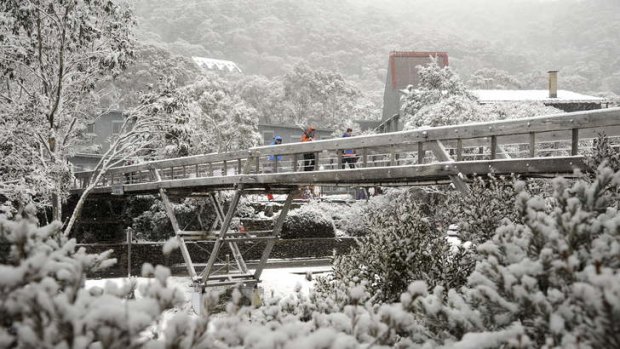
The latest cold front has dumped about 55 centimetres of snow at Thredbo, allowing the NSW resort to open all 14 of its lifts on Friday for the first time this season.
Well to the south, Victoria's Mt Buller is reporting an "incredible cover" of snow, allowing the popular resort to operate 20 of the 22 lifts in anticipation of a surge of visitor numbers.

Fresh cover: The latest cold front has dumped about 55 centimetres of snow at Thredbo. Photo: Steve Cuff/Sports Photographics Australia
Jane Golding, a duty forecaster at the Bureau of Meteorology, says the wind should drop on Saturday, making conditions ideal for snowboarders and skiiers.
"There should be some pretty clear skies up there as well over the weekend," Ms Golding said.
More snow is on the way too, with falls expected late Sunday and Monday as weekend visitors make their way home.

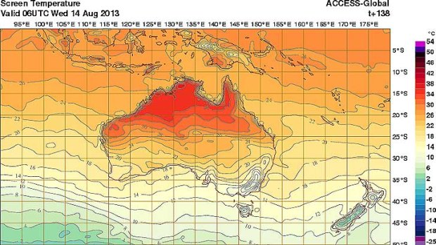
Spring-type volitile weather ahead: heat over inland Australia meets cold air from the south.
"August is probably the best month to be hitting the slopes this year with a late-season increase" in snow, said Rob Sharpe, a meteorologist with Weatherzone. Another front, arriving Saturday, August 17 or the following day "also looks fairly good at this stage," he said.
No 'disaster year'
The mild winter for most of Australia – July was a record for warmth in Sydney, Melbourne and Canberra – has been a bane for the ski resorts. Precipitation has often fallen as rain or above-zero day-time temperatures have melted much of what remained of the snow cover.
Snowy Hydro's Spencers Creek snow-depth gauge near the Perisher snowfield, for instance, had been tracking near record lows for this time of year in data going back six decades, said David Jones, head of the Bureau of Meteorology's climate monitoring.
The latest snow dump, though, doubled the weekly reading to 103 centimetres as of Thursday.
The survival of the industry, and the thousands of jobs it generates, has been increasingly reliant on artificial snowmaking to keep the ski runs open, particularly this year.
"If it wasn't for snowmaking ... the industry would have been in quite dire straits this year," said Colin Hackworth, chief executive of Australian Ski Areas Association. "Instead of having a soft year, we would have had a disaster year."
While the season has weeks to run and more snow is on the way, the number of visitors to alpine resorts will still likely be down 15-20 per cent on last year's record of 2.3 million days, Mr Hackworth said.
The industry's hope is that the arrival of spring, which often brings volatile weather, will provide a series of cold fronts to make the second half of the season much better than the first.
"This weekend is going to be the best of the season so far, but looking at the forecast, it is only going to get better from here on in," said Laurie Blampied, general manager of Buller Ski Lifts.
Across the Victorian resorts, visitor numbers were down 28 per cent on last year's record as of August 4. Buller had fared the best, down 10 per cent, while Mt Hotham - which had seen a record stretch of above-zero temperatures last month - was down 48 per cent and Mt Baw Baw off 45 per cent.
Spring-like volatility
Dr Jones, from the weather bureau, said the most significant snow often falls in spring. One reason is that the temperature differences over Australia tend to widen as spring arrives, bringing more volatile weather conditions.
Melbourne, for instance, has only recorded two snow events in a single year in recent history, with both of those coming in September 1969.
With spring, temperatures start to rise into their 30s over inland Australia. Several thousand kilometres to the south, Antarctic sea ice is nearing its maximum northwards reach, with air temperatures reaching 5-10 degrees below zero.
"You can get incredibly cold blasts right up to Christmas," Dr Jones said.
Northern and central Australia regions, in fact, are already heating up. Alice Springs, for instance, is expecting maximum temperatures ranging from 28-30 degrees over coming days, well above the August average of about 22.5 degrees.
Mr Hackworth of the Australian Ski Area Association, said the industry accepts that about one in five years will see a poor snow season. "This is one of those poor years," he said.
The industry also accepts that the trends point towards shorter seasons as the planet warms.
"We're not climate sceptics," Mr Hackworth said, adding that's why resorts have invested so much into snowmaking.
"It's a mitigation strategy, number one, against the effects of climate change, and number 2, it's (for) business security," Mr Hackworth said.
Sign up for the Traveller Deals newsletter
Get exclusive travel deals delivered straight to your inbox. Sign up now.