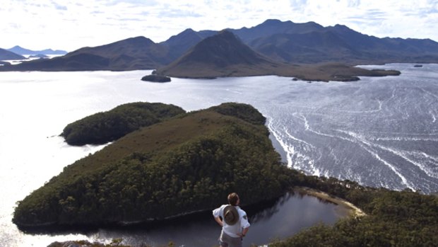
Mission accomplished ... overlooking Bathurst Harbour.Credit: Grant Dixon/Lonely Planet
Tasmania is laced with big-name bushwalking tracks that evoke images of craggy mountains, empty coasts and primeval forests. The Port Davey Track is not one of them.
Widely considered a poor cousin to the popular South Coast Track, which it meets at Melaleuca, the 70-kilometre route stretches north to south between Lake Pedder and Melaleuca, near Tasmania's southern shores. Guidebooks and websites that mention the track refer to buttongrass plains, mud and little else, underselling it by ignoring the beautiful creeks, pockets of rainforest and, most of all, the company of some of Tasmania's most spectacular mountains.
Yet the track sees only about 200 walkers a year - a number so low the track is becoming overgrown in parts - well short of the 1000 that walk the South Coast Track each season. Even the track markers have disintegrated to rusted stakes.
The sidelining of the Port Davey Track, which was cut in 1898 as an overland escape route for shipwrecked sailors, is in turn one of its assets. In the six days we spend walking the track, we see not another person. And though it might not have the beaches of the South Coast Track, all else that's best about Tasmanian walking -wilderness, mountains, solitude - is here, even if tempered by some of its characteristic features such as leeches, rain and the hungry mud of buttongrass plains.
There's nothing glamorous about a buttongrass plain, its yellowed tussocks all but floating atop a soup of mud. For the greater part of its length, the Port Davey Track cuts through these moorlands. Though it's ostensibly the easiest, flattest walk in the south-west, it's complicated by the extent of these muddy plains, dragging even 12-kilometre stretches into full, exhausting days.
We begin our walk near the shores of Lake Pedder. For the first 30 minutes the transitions in the vegetation are as abrupt as the new weights on our backs, switching between rainforest, tea-tree and buttongrass plains. There are views back over the lake to the thumb-like summit of Mount Anne, the highest peak in the south-west wilderness, and ahead to the serrated skyline of the Western Arthurs.
It's the Western Arthurs that provide much of the walking interest during the next couple of days. One of the sharpest and most abrupt mountain ranges in the country - and also the most glaciated - its traverse is widely considered to be Australia's most difficult bushwalk. What the Port Davey Track offers is a lingering look at the range without the difficulties of the traverse, sidling instead across its lower slopes, past the lateral moraines that hang from it like guy ropes.
We reach the Arthurs early on our second day, downing packs for an ambitious four-hour side trip up to their summit ridge, slogging up Alpha Moraine - the traditional approach on to the range - and then along to Mount Hesperus. The range is infamous for its fierce weather but today there are just a few rain squalls as clouds race through at formula-one speed, skimming across the top of the range.
From the ridge top, where all that seems to survive are the stunted trees that huddle behind wind-breaking boulders, south-west Tasmania opens out before us. Mount Anne and Frenchmans Cap rise to the north, while Bathurst Harbour - near to our end goal - looks impossibly distant to the south.
Back on the plain, we resume our journey south, all but afloat again in mud and buttongrass. Every few steps we seem to fall knee or thigh deep into mud holes, my boots now so crusted with mud they resemble cowpats. Overhead, a wedge-tailed eagle turns effortlessly on the currents, like nature mocking our efforts.
I think of shipwrecked sailors a century before, struggling along these plains without food, boots or spare clothes, and I wonder if more than a few might have wished they'd drowned back with the boat. There are moments in the next couple of days when I begin to side with the Port Davey Track naysayers.
But then on the fourth morning, as we climb above the leeches and mud of our camp at Watershed, we crest a low saddle near the head of the Spring River, the waterway that will now be our guiding line to Bathurst Harbour, and a new world rolls out before us.
Below sharp knolls and rocky slopes, the Spring River wriggles through a shallow gorge. Lush clumps of forest sit amid the expanse of buttongrass, giving the scene an almost tropical appearance. "Who says this is the leastspectacular walk in the south-west?" I hear somebody ask. "This is awesome."
"Even better than I remember," our guide, Brad, assures us.
From the saddle, the track sidles across the slopes of an unnamed range, suddenly above most of the mud. A tiger snake lays claim to a section of track, a freshwater burrowing crayfish strolls through a puddle and the Western Arthurs continue to peep through gaps behind. The sun fries the dry quartzite hills, giving the buttongrass the appearance of spinifex, and I'm briefly reminded more of central Australia's Larapinta Trail than anything Tasmanian.
The walking is glorious and the heat almost oppressive - a rarity you quickly learn to lap up in the south-west. Then, as we cut below the Lost World Plateau, I fall thigh deep again into mud, the deepest and stickiest quagmire of all, and I know I'm back in Tasmania.
"I've worked out why they call it the Lost World Plateau," says my walking partner, Martina, who'd taken minutes to extract herself from one bog. "Worlds have been lost in those mud holes."
From the site of our camp - tonight beside the Spring River, just 14 kilometres but nine hours' walk from Watershed - the Port Davey Track diverges from the original shipwreck route, which continues along the valley to Bathurst Harbour. Instead, the track changes character, climbing to follow a line of open ridge tops and dropping sharply into valleys between to remind us that we're still surrounded by the world's sixth ocean: the south-west sea of mud.
A fierce north wind blows and an inlet on Bathurst Harbour is visible from the beginning, a cool talisman drawing us forward on a hot day. By our final climb of the day, across the shoulder of Lindsay Hill, the wind is at gale force, gusting to 100km/h, and the temperature is 36 degrees. Along the ridge it's impossible to walk straight. Martina can't even stand. She drops her backpack for her partner, Glen, to retrieve and all but crawls to the top.
We catch our breath in the lee of the hill, then make a wind-buffeted descent beneath Mount Rugby's bouldery slopes to the shores of Bathurst Harbour. Waves crash ashore even though we are 10 protected kilometres from the open sea.
To cross the Bathurst Narrows, we must row a boat but in this wind we're going nowhere. So we camp on the shores, thrashed by wind, and celebrate New Year's Eve with a bottle of sparkling wine Glen has carried for five days, drinking it from enamel mugs.
In true bushwalking form, we're in bed three hours before the new year arrives.
The wind blows itself out in the early hours of the morning and by 10am we're able to row across the harbour's waters, in which the dark, tannin-stained freshwater overlies the saltwater, preventing light from filtering through and creating deep-sea conditions in less than10 metres of water.
Across the harbour we again splash through buttongrass plains until Melaleuca appears mid-afternoon, its airstrip and Nissen huts almost qualifying it as a metropolis in the vacant south-west. Martina has been here before, having twice walked the South Coast Track and now, for the first time, its silent partner.
"I think this is at least as spectacular as the South Coast Track," she says. "It's very different but just as good."
A plane skims low over our heads, returning bushwalkers to Hobart. To the north, the distant peaks of the Western Arthurs saw at the sky. Behind me I hear a splash and a yelp. Somebody has fallen into a mud hole.
The writer travelled courtesy of Tasmanian Expeditions.
Virgin Blue flies to Hobart for $59 from Melbourne and $85 from Sydney. Qantas has fares for $123 from Melbourne and $182 from Sydney. Tiger Airways flies from Melbourne only from about $35. (Fares are one way, including tax.)
Walking there
Tasmanian Expeditions runs seven-day bushwalking trips along the Port Davey Track for $2195, including professional guides, all meals, accommodation, equipment and a scenic flight. The walk can be combined with the South Coast Track, making it a 16-day bushwalk ($3595) through the south west. Phone 1300 666 856 or see tasmanianexpeditions.com.au.
Sign up for the Traveller Deals newsletter
Get exclusive travel deals delivered straight to your inbox. Sign up now.